Part IV, From Geiranger to Alesund
挪威四,从盖朗厄尔到奥勒松

Geirangerfjord
We arrived at the amazing Geiranger on June 28. Not only was the fjord itself magnificent, but there were also other attractions. As one of the National Tourist Routes, the Old Stryn Mountain Road or Gamle Strynefjellsvegen (rv258) is another must for most tourists.
6月28日抵达著名的盖朗厄尔。这里不仅有壮观的峡湾,还有其他重要看点。 作为国家旅游路线之一的老斯特林山路(rv258)是大多数自驾游客的另一必游之境。
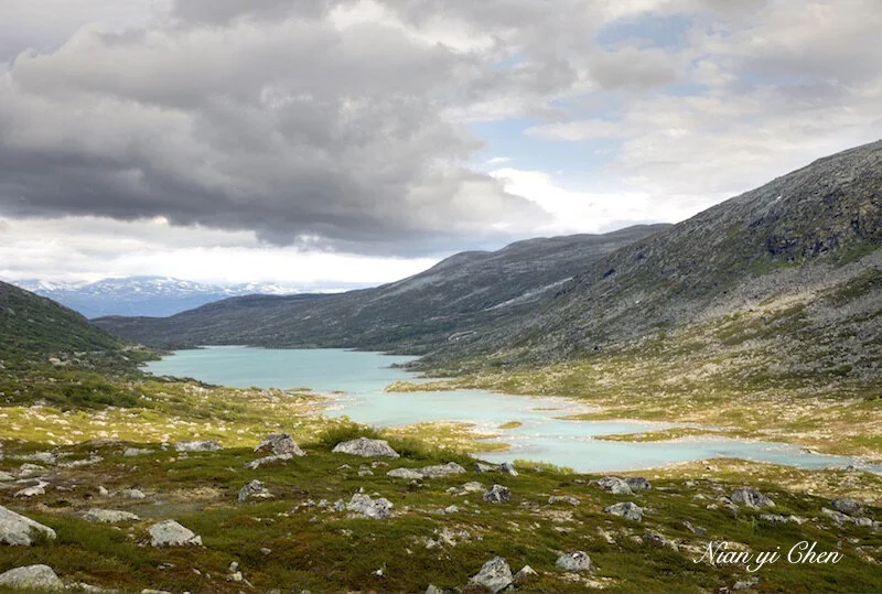
June 29th. From the town of Geiranger, we drove out to the Old Stryn Mountain Road (rv258) via fv63 (which is always pretty).
6月29日。 我们从盖朗厄尔镇出发,经由fv63(全程都很漂亮)开往老斯特林山路(见下图)


Norway’s Rv258 is known as Gamle Strynefjellsvegen (Old Stryn Mountain Road). It runs 27-kilometres between Stryn and Grotli. Again this stunning scenic drive is closed in winter and reopens in June of the next year. We were fortunate to be here in July of 2019.
挪威的Rv258被称为老斯特林山路。 它是连接斯特林镇和格罗特利镇的27公里风景路段。像很多北欧旅游景点一样,这条美到极致的自驾路线会在冬天关闭,并于次年6月重新开放。 我们很幸运地于2019年7月造访了这里。

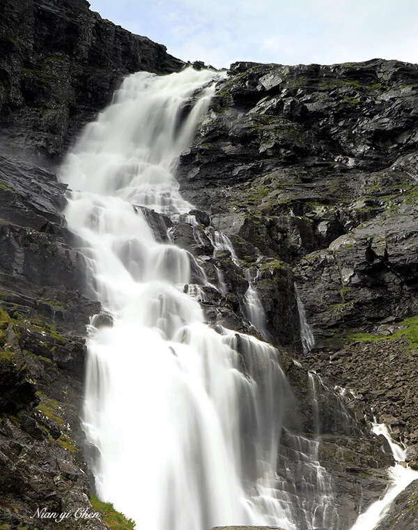
In the summer, Gamle Strynefjellsvegen runs by a half-melted ice river. The greenish blue water by melting glacier is mesmerizing.
夏季里,老斯特林山路与一条半融化的冰河并行。源自冰川的蓝绿色河水美得令人目炫。


Gamle Strynefjellsvegen continues onto highway 15 which leads to the town of Stryn, a beautiful little town which we wish to could have stayed for one night.
老斯特林山路与15号公路相延续,并通往美丽的斯特林镇(Stryn)。

Stryn is a very prosperous town. Here you can find many hotels, restaurants and a big shopping mall. It’s a good place to spend a night or stop for lunch. We stopped here for two hours in the middle of the day and had a great lunch in the mall. Near Stryn on highway 15, there is a big beautiful lake, Lake Strynevatnet.
斯特林是一个繁荣的小镇。 这里有旅馆,餐厅和大型购物中心,是一个留宿一晚或停车午餐的好地方。 我们在这里消磨了两个小时(可惜不能留宿一晚),并在购物中心享用了可口的午餐。 斯特林的附近有一个美丽的大湖,斯特涅瓦湖(Lake Strynevatnet)。

Lake Strynevatnet
After a long lunch break we drove back to Gamle Strynefjellsvegen for the afternoon lighting.
午餐后,我们重回令人流连忘返的老斯特林山路


Driving fv63 back to Geiranger
然后沿63号公路返回盖朗厄尔。


Djupvasshytta Hotel
We passed the above hotel on Fv63 and believed this would work better than our hotel in Geiranger.
Fv63途径这个路边旅馆(Djupvasshytta Hotel),看起来会比盖朗厄旅馆好些。
We stayed two nights in Hotel of Geiranger, which we wouldn’t recommend because of the noise.
我们在盖朗厄尔宾馆住宿了两晚,但不推荐这里,因为环境较嘈杂。
June 30th, from Geiranger, we set out towards Trollstigen. From Geiranger to Trollstigen (145 km on Fv63) is known as “The Golden Route" of north Norway and is another one of the 18 National Tourist Routes.
六月30日,我们离开盖朗厄尔前往特罗尔斯蒂根(精灵之路)。从盖朗厄尔到特罗斯蒂戈的145公里山路被誉为北部挪威的“黄金之路”,也是18条挪威经典国家旅游线路之一。

The drive along Geiranger–Trollstigen is more dramatic than most of the other National Tourist Routes.
在这条路上行驶比其他国家旅游公路更感到惊心动魄。

The very beginning part of this route (northwest of Geiranger) is the world famous Eagle Road. This is the name given to the steepest stretch of road up the mountain side of Geiranger.
这条路的起始段(盖朗厄尔之北)就是世界著名的老鹰之路。这是盖朗厄尔湾山崖侧陡峭向上的一段山路。其得名是因为早前这里的山巅上曾经是大量老鹰的集居地。
It was called Eagle Road because at its highest point, the terrain had traditionally been the domain of a large number of eagles.
The Eagle Road swings through eleven hairpin bends up from the Geirangerfjord to the highest point, Ørnevegen, 620 metres above sea level at Korsmyra. Due to the poor weather and the difficult driving conditions, we had no pictures for this road besides the ones on the very top.
老鹰之路是山崖上经过11道拐扶摇直上的崎岖道路。它的顶端是海拔620米的厄尔涅维根(Ørnevegen)景区。这段路的行驶十分艰苦,但到得山顶时却得到意外的惊喜。
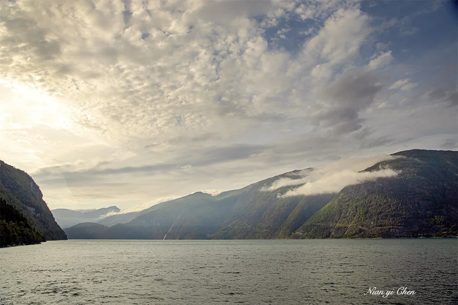
Once we got to Ørnevegen, the sky cleared up a little and we found a large parking lot and a long spectator that offers a 180-degree view of Geirangerfjord. To the left, one gets a spectacular view of the fjord and to the right , a view of Dei Sju Systre (the Seven Sisters) waterfalls.
当我们辛苦抵达山顶时恰好云开日出,得以目睹盖朗厄尔峡湾迷人的风采。长长的观景台那天人头攒动,向左可以俯瞰整个峡湾,向右则是另一著名景点七姐妹瀑布。


Geirangerfjord

The Seven Sisters Waterfalls, part of Geirangerfjord
Unfortunately we didn’t hear about the fjord cruise that can take you close to the famous waterfalls.
可惜我们事前不知道可以乘船游玩峡湾,并到达那著名瀑布的近前。

After Ørnevegen, we continue northward to Eidsdal (below) where we took a ferry that crosses Norddalsfjorden to reach Velldal.
厄尔涅维根(Ørnevegen)之后,我们继续向北至艾兹达尔(Eidsdal)(下),从那里坐渡轮穿过Norddals峡湾前往韦德尔(Velldal)。峡湾之国的挪威轮渡发达,多数渡轮都可以接载车辆。游客开车上船后可以下车休息或上甲板观景。

Norddalsfjorden 穿越峡湾
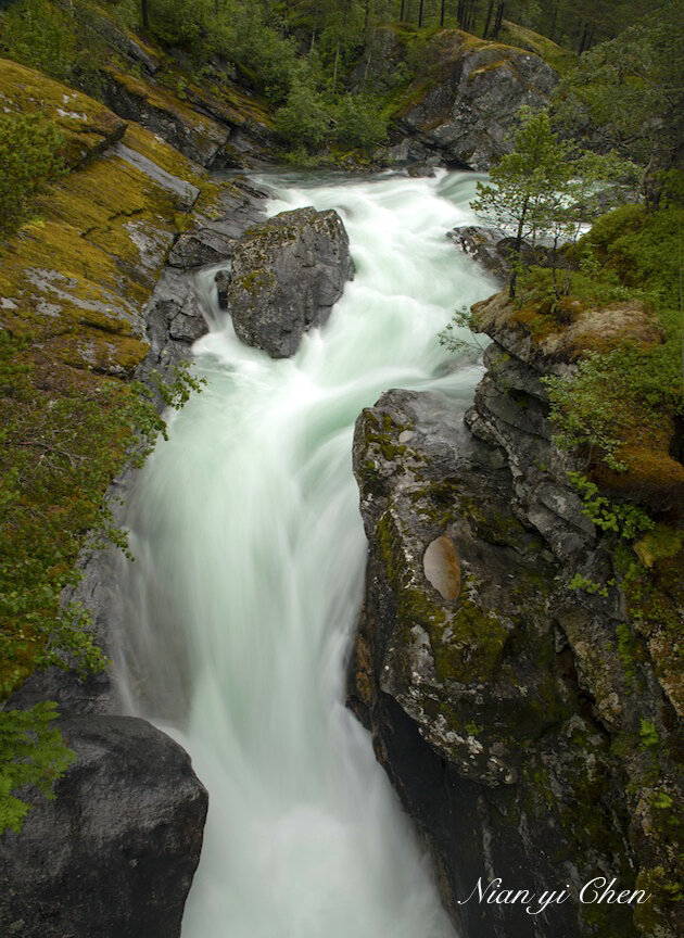
From Velldal to Trollstigen, we stayed on Fv 63 which passed several pretty rivers and creeks.
从韦德尔(Velldal)到特罗尔斯蒂根(精灵之路),我们继续在63号公路上开,路径好些湍急的河流。

It was foggy and rainy when we arrived Trollstigen. The visibility was so poor that we couldn’t seen anything in front of us. We drove further down the road to the nearby town of Åndalsnes and stayed in Grand Hotel Bellevue (very good!).
我们到达特罗尔斯蒂根时遭遇雨和大雾(北欧多雨), 能见度极差,近距离内都看不到任何景物。 我们于是继续前行至翁达尔内斯(Åndalsnes)镇,并在Grand Hotel Bellevue住下(非常好)。
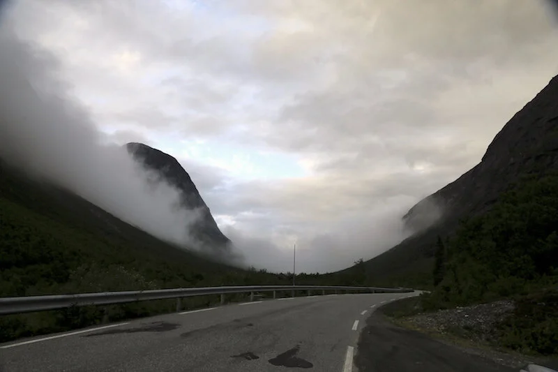
July 1, we drove back to Trollstigen. It was still cloudy, but the visibility was better. It was scenic all the way.
七月一日早晨,重返精灵之路,虽然天气仍是阴沉,但能见度尚可。从翁达尔内斯到特罗尔斯蒂根一路风景宜人。


Trollstigen is part of the Norwegian Scenic Route Geiranger - Trollstigen. Again, it opens at the end of May and closes in October / November.
This is a winding mountain road that crosses many creeks and waterfalls and takes you up to the spectator on the mountain top. Each of the 11 hair-pin turns has its own name and offers fantastic views of mountain scenery.
又名“精灵之路”的特罗尔斯蒂根是一条曲折陡峭的山路,历经11道拐带你跨越溪流瀑布和古老石桥来到海拔852米的观景台,沿途风景震撼动人。
山路上的11个发夹弯道每个都有自己的名称,通常以监督该特定部分的施工人员的名字来命名。


While we were driving up the mountain, the rain was on and off, leaving the road wet and slippery. Many Volunteers were working at each tun to direct the traffic.
那天仍然阴雨,山路湿滑,有很多志愿者在路边停车点指挥和协调车流。

Hard working cyclists riding all the way to the top of Trollstigen.
勇敢的单车爱好者在恶劣的天气里奋力蹬车到山顶,令人起敬。
对登山爱好者来说,这里有一条经过修复的远足路径。 这条经过翻新的古老山路可以直达山顶。


Once at the top, you walk through a well constructed facility (top left) to the spectator (top right) where you get panoramic views over the valley and waterfalls.
山顶上有诺大的停车场,餐厅和旅游商场。游人们可以走过长长的,修缮精美的栈道前往观景台。从观景台可以俯瞰整个山谷和瀑布溪流,景色壮观,令人难忘。


Together with Geiranger, the world famous Trollstigen is one of the most visited attractions in Norway.
和盖朗厄尔一样,特罗尔斯蒂根精灵之路是挪威受访最多的景点之一。

Back to Åndalsnes from Trollstigen, we continued to be awed by the dynamic scenery.
从特罗尔斯蒂根返回翁达尔内斯的旅途仍然使我们多次驻足不前。


Åndalsnes (翁达尔内斯)
We ended up spending one extra night in Åndalsnes due to the weather. It’s a small town idyllically located in the valley of Romsdal by the Romsdalsfjord. It is surrounded by high mountains and is very scenic. Unfortunately we didn’t have enough time to explore it.
翁达尔内斯是罗斯达尔峡湾边上的一个恬静的小镇,河流纵横,群山环绕。可惜我们没有时间多作探访。
July 2 We left in the early morning from Åndalsnes for Ålesund.
七月二日晨我们离开翁达尔内斯开车前往奥勒松
(Ålesund)

奥勒松(Ålesund)是挪威西海岸的海港和枢纽城市。这里有航班飞往各重要城市。

Aksla on the mountain top gives you an impressive view of the city of Ålesund。
奥勒松室内有个地处山顶的景点阿克什拉(Aksla)。这里你可以居高临下地观赏美丽的奥勒松市。

From Ålesund, we flew to Lofoten to start the last leg of our trip in north Norway.
从奥勒松我们将飞往罗弗敦(Lofoten),去完成挪威北部的最后一程。
To be continued
待续